Software solutions

Convenient software for real precision agriculture

Software for everybody - whether it’s just for ISOBUS machine control alone, or for precision farming functions - the AmaTron 4 offers various different optional software licences that can meet every challenge. All licences are pre-installed on the AmaTron 4 and can be trialled free of charge or activated directly for a fee.


GPS-Maps&Doc with data exchange via the AmaTron Share App

With the GPS-Maps&Doc licence, the AmaTron 4 can gather and document both machine data and georeferenced data via Task Controller (TC). Job data, such as field boundaries or application maps, can be imported and processed conveniently using the central import menu in either the ISO-XML or Shape file format. The motto here is: work first, then save or delete.

After importing an application map, you can immediately start work in the field without having to create a job in advance.

When the task is finished, the job can be saved on the terminal or exported in either ISO-XML or PDF format. The ISO-XML Export can then be imported into a Farm Management Information system for documentation purposes. The PDF export can be saved. A PDF report can be created for each job for documentation purposes.

  • The AmaTron Share App, which is connected to the AmaTron 4 via Wi-Fi, allows all data to be imported and exported easily online.

Generation of an application map in a farm management information system and automatic part-section-specific control of the application rate with the AmaTron 4

More information + Less information -

GPS-Switch

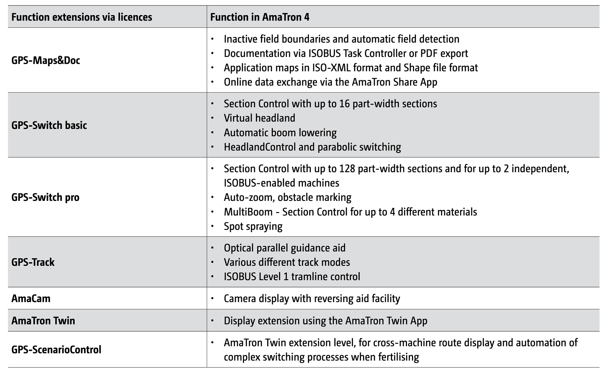
The automatic part-width section control, GPS-Switch from AMAZONE enables GPS-based, fully automatic part-width section control for your ISOBUS machinery. In automatic mode, the part-width sections are switched on and off automatically in wedge shaped fields, at headlands or on field boundaries. On the one hand, this reduces the driver's workload and, on the other hand, input costs are reduced as there are less overlaps and fewer misses. The work in the field is more precise. GPS-Switch is divided into the GPS-Switch basic and GPS-Switch pro licences, and these are characterised by different functionalities.


Automatic part-width section control on the virtual headland (orange border) with GPS-Switch basic. This allows the inside of the field to be worked first and then the headland, e.g. when sowing.

GPS-Switch basic

  • Automatic part-width section control of up to 16 part-width sections 
  • Creation of virtual headlands  
  • GPS-based recording of the worked area 
  • Generation of field boundaries


MORE than ISOBUS

  • AMAZONE fertilisation: Parabolic switching of the part-width sections and HeadlandControl headland management 
  • AMAZONE plant protection: automatic boom lowering 
  • AMAZONE seed drills: MultiSwitch - single row switching for up to 16 part-width sections for fertiliser, seed and microgranules


GPS-Switch pro (as an extension of GPS-Switch basic)

  • Section Control with up to 128 part-width sections and for up to 2 independent, ISOBUS-enabled machines 
  • Marking of obstacles, e.g. water holes, pylons 
  • Auto-zoom when approaching the headland 
  • MultiBoom - individual switching times via Section Control up to a maximum of 4 booms
  • Spot spraying


In crop protection, individual nozzle shut-off and GPS-Switch means that 50 cm part-width sections can be switched automatically. With this system, the degree of overlap is significantly reduced and, in comparison with conventional part-width section control, is up to 85 % less (depending on the field size, working width and the number of part-width sections).


With MultiBoom, the metering units for the various different hoppers are switched on and off at staggered intervals via GPS-Switch pro during seeding to avoid overlaps and gaps for each application material. The staggered switching of the fertiliser coulters, sowing coulters and micro-granular applicator is visualised on the AmaTron 4 by the part-width section status.

More information + Less information -

GPS-Track

The GPS-Track parallel guidance aid facilitates orientation in the field, especially on grassland where there are no tramlines. In the possible track modes, A-B Line and Contour line driving, the passes are shown as clearly numbered. Deviation from the ideal line is displayed with clear steering recommendations by the light-bar in the status bar on the AmaTron 4, see image on the right.

GPS-Track also enables ISOBUS Level 1 tramline control for seed drills, as an alternative to tramline control via track markers or a working position sensor and as an option for working in lands.

More information + Less information -

App AmaTron Twin - the convenient display extension

The AmaTron Twin App offers the driver even more comfort during work, as GPS functions in the map view can also be operated via a mobile device (e.g. a tablet) in parallel with machine operation in AmaTron 4.


Advantages of the AmaTron Twin display enhancement: 

  • Use of an existing, mobile device 
  • Greater clarity – all applications in view 
  • Comfortable control of GPS functions in the map view in parallel via the mobile device 
  • Clear, authentic representation of the working machine and its part-width sections
More information + Less information -

GPS ScenarioControl

GPS-ScenarioControl is an extension to the AmaTron Twin licence, for which you will also need the AmaTron Twin. This terminal software is for automating complex and recurring switching processes in the field.

With its route function, GPS-ScenarioControl makes for easier orientation of all machines in the field. In addition, in combination with AMAZONE ISOBUS fertilisation, certain switching operations (edge, boundary, water-course spreading and HeadlandControl) can be automated, thus preventing operating errors.


Advantages with GPS-ScenarioControl: 

  • Reduced workload by following a previously plotted scenario 
  • Always the same switching processes on every pass in the field 
  • Prevention of operational errors 
  • Always the same route for all crop care applications in the field and thus no driving over the crop by taking a wrong turn

Field with complete route display and saved georeferenced switching points. 
When moving over the switching points, labelled as pins, the machine function stored in each case is automatically activated or deactivated. Tapping on the switching point opens a menu in which the function to be activated or deactivated is marked. Water-course spreading is activated on the left-hand side here.

More information + Less information -