GPS-Maps&Doc
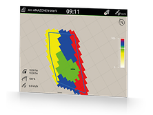
GPS-Maps&Doc offers field-related and geo-referenced documentation via Task Controller. Scheduled ISO-XML jobs can be processed or created via Task Controller. You can start working straight away and decide later whether the data should be saved or not. Application maps can be processed in the ISO-XML or Shape file format. After the work has been completed, the jobs can be exported in ISO-XML or pdf format via a USB stick for documentation. For ease of orientation, inactive field boundaries are displayed in the map view and fields are automatically recognised on approach. Activate with a click and off you go!
The AmaTron Share App, which is connected to the AmaTron 4 via Wi-Fi, allows all data to be imported and exported easily online.

